Sunday, September 2, 2012

Day 15: Barstow, CA to Santa Monica, CA

So our final leg today started in Barstow, CA.

Barstow being a bigger city and still located in the desert, we were able to find lots and lots of motels along the main 4-lane road through the city.

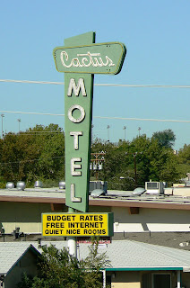
The Cactus Motel in Barstow, CA
The Village Hotel and Cafe downtown Barstow, CA
It has been really amazing to find the abundance of motels in the larger cities in Arizona and California. It really shows the importance of their presence back when Route 66 was THE road to travel on.

Mural on one of the buildings in downtown Barstow, CA


Private residence of someone that bought an old
gas station and made it his house - near Helendale, CA
After we left Barstow, we hit up several smaller towns with very few relics available. In one of the towns though, we found a house which was obviously an old gas station at one point. As we started taking pictures, the owner came out - this is when we found out this was actually a private residence.


Route 66 near Cajun Summit. The old road still curves the
mountain hill.

The guy bought it for $22,000 about 30 years ago with only the walls standing at that point. He improved it from there but kept the original walls as much as possible. He got so into it that next to his house, he built a make believe western scene with a saloon and everything. He mentioned that he got offered a lot of money for his house but he just didn't want to sell. It was pretty amazing to see what he did to that house.


Bottle Ranch near Helendale, CA


A little further, we found a guy that has a bottle ranch - basically, a piece of land where he made sculptures from empty bottles. Some were pretty basic but others where really cool looking.


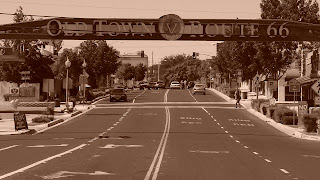
Sign above the old town of Victorville, CA


Next we got to Victorville - a town that had some really nice signs and murals posted all over their old historic district. Some of the murals were really amazing and displayed the items you would encounter on the road.


Mural on one of the buildings downtown Victorville, CA - depicting the eight states Route 66 travels through
Foothill Blvd on the way to Los Angeles 

From there, we hit San Bernardino and the main boulevard, Foothill Blvd, through many towns towards the coast. It is about 50 miles from here towards the end of the route and hitting a stop light every quarter mile doesn't make for the most fun drive by any means.
The Wigwam Motel in Rialto, CA


These towns being the suburbs of Los Angeles make them obviously very populated and finding old relics from the old days is like looking for a needle in a haystack. There are some left, nevertheless, even though many have lost their neon signs and colors over the years.

Marker on Foothill Blvd towards
Santa Monica
Some towns really make you know that you are driving the Mother Road through their town, others you wouldn't have a clue.

I didn't take that many pictures along this stretch of the road - partly because there weren't that many and also because traffic gets really busy and there aren't that many places to pull over for a bit.

The Will Rogers Highway marker at the end
of Route 66
We eventually got to Pasadena, and from there around downtown Los Angeles, through West Hollywood, Beverly Hills, and into Santa Monica. As we approached the end of the road, we could feel the temperature drop down to the mid seventies - a sign we were getting near the ocean. We parked the car and walked the final yards to the end marker and a view of the Pacific Ocean.


Santa Monica pier. WE MADE IT!!!!

I still can't believe we made it after all these years, but yet here we are. I got to be honest - it has been a lot of driving and so I'm glad the end is here. It has been an amazing trip though and I will have memories for years to come.

Miles driven today: 165
Time driven today: 6hrs 20min

Total miles driven: 2,113
Total time driven: 66hrs 25min

Friday, August 31, 2012

Day 14: Kingman, AZ to Barstow, CA

Route 66 in the Mojave Desert

Only about 60 miles from Kingman to the California state line but what a 60 miles it is.

The Hill Top Motel in Kingman AZ
The Orchard Inn Motel in Kingman, AZ
Since we stayed on the east-side of Kingman last night, we started off by driving through the city.


Kingman has a lot Route 66 woven into its history and this was very evident by the many businesses that are still alive today.

We still saw several motels and restaurants from the hay day and their historic downtown had many activities around Route 66.


Stretched out section of Oatman Highway
After Kingman, one enters the Oatman Highway - a long stretch of Route 66 towards California that deviates from the interstate completely. The first 20 miles or so are through the Arizona desert before we got to the Black Mountains.


Route 66 through the Black Mountains in Arizona


This is where Route 66 really took us for a spin with hairpin turns, narrow roads and no fence next to us. The heat started to crawl up to the 100 degrees here. However, this passage was very nice to drive and we got some great views on either side of the Black Mountains of the valleys below.


Small town of Oatman, AZ

I know it's not polite to take a picture of a nursing
mother but I couldn't help myself
About 5 miles into the mountains, we got to Oatman, a town once dedicated to gold mining, but has now been completely converted to tourism. The old buildings (western style) are all still there and there are many attractions one can see. We happened to arrive at the time when a gun fight show-down was about to happen so we stuck around for that.

Le Brun Motel in Needles, CA

We did have to watch out for the wild burros that are walking around in the town, trying to get food from whomever they encounter. They are tame enough to approach you but we got warned several times by the locals that they do bite and kick when they get annoyed.

Welcome sign to Needles, CA
After Oatman, we got back on the road through the Black Mountains and made our way down to the Colorado River and the natural divider between Arizona and California.

Once we crossed the Colorado River, we got to Needles, the first city on Route 66 in California. Lots of history here again with dozens of motels along the route. We also saw several really nice murals throughout the city that were displaying scenes of what the road would have brought.

Mural of pretty much the route we took today - on top of a grocery store in Needles, CA

The Mojave Desert
From there, we took the National Trails Highway across the Mojave desert. The temperature quickly started  rising, hitting a peak of 109 degrees/43 celsius according to the temperature reader in our car. And of course, there was nothing in front or behind us - just a long stretch of road along the railway.


Abandoned grocery store in Essex, CA
After dozens of miles, we started hitting some old towns, some completely abandoned, in the middle of the desert. Most of them had at least one motel and a gas station - signs that Route 66 had a significant purpose for these towns.


Ruins of a gas station/garage in Cadiz Summit, CA


In Goffs, the only thing we found was an abandoned gas stations and motel. In Essex, the sign claimed the city has 100 people living it, even
though we could barely find a couple houses that did not look completely abandoned or burned down. Danby just had an old abandoned gas station.
Roy's Motel and Cafe in
Amboy, CA
Abandoned Motel in Goffs, CA


Cadiz Summit had a couple ruins of an old gas station/garage, completely covered with graffiti.

Amboy looked like a hopeful rest place in the middle of the desert with its amazing tall sign, yet the school was all boarded up and the steeple on the church was crooked because it was sunken in.

There's me....
The gas station was still open for business and happily serving gas at 5.09 for unleaded when the nationwide average is 3.83. I guess when you are in the middle of the desert and you need gas, you don't really care what the price is.


.... and my dad, Frank

Around Chambless through Amboy and  beyond is what our guide calls the "Route 66 Public Art Corridor." It is miles and miles of a dirt berm where hundreds of travelers have written their name in the dirt with rocks found alongside the road.


It was pretty neat to see and given that we were are close to finishing Route 66, we had to leave our mark as well. So in the 104 degree weather in the middle of the desert, we began collecting rocks to write our names, hurrying up to get back in the air-conditioned car. I wonder how long we will be part of the landscape here.....

There are miles and miles full of names


Entrance to Calico Ghost Town
As we got closer to Barstow, our final stop for the day, we came really close to Calico, a ghost town near Daggett. Calico used to be a mining town for silver and is located up near the mountains. It has a particular meaning to me because exactly 20 years ago, I came to the U.S. for the first time with my family to tour the entire West coast of the United States.


Downtown Calico. You can see the name written
on top of the mountain
We started off in Los Angeles and made our way up to Washington state to then come back down to San Francisco. One of the early stops we made was to visit Calico and although I was 12 at the time, I vividly remember visiting this ghost town.


So it was only appropriate that I would revisit this with my dad this time. While the town "closes" at 5pm, you could still drive in and walk around, which is what we did. There were many things we still remembered from the first time we were here and it was nice to relive these old memories. As we drove away, my dad and I started reviving some of the segments of the trip we made then and the route we took. I can only imagine we'll do the same about this trip sometime in the future.

Miles driven today: 261
Time driven today: 7hrs 15min

Total miles driven: 1,948
Total time driven: 60hrs 5min

Thursday, August 30, 2012

Day 13: Flagstaff to Kingman, AZ

Street sign in Kingman, AZ

Today's leg of Route 66 took us further through Arizona. I'm really liking this state and the scenery that we encounter along the way.


The Western Hills Motel in Flagstaff, AZ


We left Flagstaff this morning and as we were driving through the city, we encountered several motels along the way.
The Downtowner Motel
in Historic Flagstaff, AZ
Not too many relics left though in the new part of town. In the historic district, however, you could find several motels and restaurants and other buildings from back in the day that were preserved.


Old abandoned segment near
Bellemont, AZ disappearing
under interstate I-40
From there, we hit the road towards Williams. The drive was through nice stretches of pine tree forests, far enough from the interstate to make you feel in no-mans-land. A couple miles outside of Flagstaff is the small town of Bellemont. There we found an abandoned piece of Route 66 that led straight to go under the interstate.

Highest point of Route 66 in Arizona
at 7,410 ft in Parks, AZ
A little further after that, close to Parks, AZ, we hit the highest point of Route 66 in Arizona at 7,410 feet. The nice thing about it as well is that it lies on a dirt road in the middle of a forest.


Parks has really tried to preserve Route 66 as well as possible and they created an Auto tour of where the original 1920's pavement once crossed that section. No cars allowed, but we hiked the piece. Some of the pavement was still there, but other pieces were just scraped up and the pavement was tossed to the side.

Welcome sign in Williams, AZ
Williams was next on the list and this town is Route 66 overload.
Red Garter, an 1897 bordello, with a manikin
hanging out of the window in Williams, AZ

Everywhere you looked, they had signs, little neighborhoods, buildings, restaurants, motels, gas stations and everything in between dedicated to Route 66.

Their welcome sign said it all: "The best of Route 66." There is definitely a lot of history here.

The Cafe 66 downtown Williams, AZ


The Supai Motel in Seligman, AZ

The next town, Seligman, didn't want to be the underdog, and had very lively signs of Route 66. Besides the several motels that we saw, they had a huge souvenir store that had Route 66 plastered all over it.

Guy signing "Get your kicks on
Route 66" in Seligman, AZ
We pulled over and hung out for a bit. There was live music playing and many other visitors of Route 66 hanging out.

The picture I took was of a guy playing "Get your kicks on Route 66" - very appropriate for the moment.


Looking up into the cave where
condensation created this erosion
From there, we hit a long stretch of 66 through the Arizona plains between a couple mountain ranges and made our next stop at Grand Canyon Caverns. No city here, just a recreation place to visit the largest dry caverns in the United States and the third largest in the world.
The Snow Palace - soft mineral bubbles forming
 on the ceiling of the cave

20 ft sloth, whose bones were found in
this cave
They are not that far underground, about 100-200 feet but pretty stretched out. They were originally called Dinosaur Caverns for the bones that were found that were thought to be from dinosaurs yet later discovered to be from a sloth dating back from the Ice Age. Later however, the then owner wanted to know where the airflow in the cave was coming from. He lighted several signals of red smoke and left a crew up on the ground to see where it would appear.

Bobcat that fell in the cave and was preserved
Two weeks later, nothing had appeared so the crew left. Shortly thereafter though, they got a phone call that red smoke was coming out of the walls of the Grand Canyon. The caves were therefore renamed Grand Canyon Caverns. Side note that the Grand Canyon is about 120 miles from this place. Another neat thing is that you can stay overnight inside the cavern, all decked out with tv and all the bells and whistles.

The Lido Motel in Kingman, AZ
We drove through a couple more small towns and along a nice stretch of the road.

Route 66 Motel in Kingman, AZ
The road is taking us through many hills and while the stretch we are driving is a newer piece of 66, we can see scattered pieces of the old original road zigzagging around us and around the hills.

The old road is in very bad shape though and many pieces are missing and eaten up by the landscape.


Our stop today is in Kingman. We haven't explored the full portion of the road yet in this city, but as we were driving in, we saw a couple motels already welcoming us to rest here tonight.


Miles driven today: 172
Time driven today: 4hrs 30min

Total miles driven: 1,687
Total time driven: 52hrs 50min